 GeoMAP is a collection of datasets comprising geological information for Antarctica, including both rock and surficial deposit information. They have been compiled by the GeoMAP team led by GNS Science. This work utilised co-funding from GNS Science’s Nationally Significant Databases and Collections Programme (NSDC) and international collaboration through the SCAR GeoMAP project.
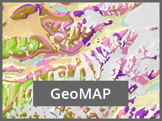
GeoMAP represents a synthesis of existing published and unpublished mapping of the geology of the Antarctic continent in a single geodatabase at a regional scale. The data comprises geological unit polygon geometry and attribute fields describing the unit type, name, age, lithology, stratigraphy, and supporting background information, where this is known, and geological fault polyline geometry and attribute fields describing locational accuracy, exposure, fault type, and supporting background information, where this is known.
Access the GeoMAP Download Page
Access GeoMAP Metadata
Access detailed GeoMAP documentation
GeoMAP material is licensed under a Creative Commons Attribution 4.0 International License. The following citation for GeoMAP.v.2022-08 is suggested:
Cox, Simon Christopher; Smith Lyttle, Belinda; Elkind, Samuel; Smith Siddoway, Christine; Morin, Paul; Capponi, Giovanni; Abu-Alam, Tamer; Ballinger, Matilda; Bamber, Lauren; Kitchener, Brett; Lelli, Luigi; Mawson, Jasmine F; Millikin, Alexie; Dal Seno, Nicola; Whitburn, Louis; White, Tristan; Burton-Johnson, Alex; Crispini, Laura; Elliot, David; Elvevold, Synnove; Goodge, John W; Halpin, Jacqueline A; Jacobs, Joachim; Mikhalsky, Eugene; Martin, Adam P; Morgan, Fraser; Smellie, John; Scadden, Phil; Wilson, Gary (2023): The GeoMAP (v.2022-08) continent-wide detailed geological dataset of Antarctica. PANGAEA, https://doi.org/10.1594/PANGAEA.951482
A GeoMAP web-based explorer can be accessed directly through Antarctic Explorer.
For queries about GeoMAP, please get in touch with the GMNZ Data Manager.