Publications, Data and Links of interest to the Southern Ocean Bathymetry Community
+ Publications
IBCSO reports:
-
pdf IBCSO Expert Group Report 2022 Popular
-
pdf IBCSO Report 2020 Popular
-
09 September 20201.45 MB768 downloads
-
pdf Poster presentation at XXII ISAES Popular12 August 20151.14 MB1399 downloads
-
22 October 20134.78 MB976 downloads
-
01 April 20133.55 MB1154 downloads
-
12 March 20133.42 MB1077 downloads
-
12 September 20123.54 MB1233 downloads
-
12 March 20125.42 MB958 downloads
Other Publications:
-
Poster presentation at the EGU Spring Meeting 2020: Hehemann, L., Arndt, J. E., and Dorschel, B.: IBCSO V2.0: An updated Antarctic bathymetry product of Seabed 2030, EGU General Assembly 2020, Online, 4–8 May 2020, EGU2020-3529, https://doi.org/10.5194/egusphere-egu2020-3529, 2020
-
pdf Poster presentation at XXII ISAES (1.14 MB) , 16. July 2015. Open Poster.
-
pdf Oral presentation at the Eighth Annual GEBCO Bathymetric Science Day (4.78 MB) in Venice, 8. October 2013.
-
IBCSO V1.0 Release Paper: "The International Bathymetric Chart of the Southern Ocean (IBCSO) Version 1.0 - A new bathymetric compilation covering circum-Antarctic waters", Geophysical Research Letters, doi: 10.1002/grl.50413, Arndt et al. 2013
-
document Oral presentation at the "25. Internationale Polartagung der DGP" in Hamburg (3.55 MB) , 20. March 2013.
-
pdf Poster presentation at the AGU Fall Meeting (3.42 MB) in San Francisco, 7. December 2012.
-
pdf Oral presentation at the XXXII SCAR and Open Science Conference in Portland (3.54 MB) , 16. July 2012 entitled 'IBCSO v1 - A preview of the International Bathymetric Chart of the Southern Ocean'.
-
pdf Poster presentation at the AGU Fall Meeting (5.42 MB) in San Francisco, 5. December 2011.
-
Oral presentation at the Intergeo 2008 HTML logo.png, Bremen, Germany, October 2008.
-
Oral presentation by Ott and Schenke entitled 'Polar Ocean Mapping: Significance of Bathymetry for Observing Systems' at the SCAR/IASC Open Science Conference, St Petersburg, Russia, 8-11 July 2008.
-
Poster presentation at the SCAR/IASC Open Science Conference, St Petersburg, Russia, 8-11 July 2008.
-
Joint IBCAO and IBCSO poster presentation at the SCAR/IASC Open Science Conference, St Petersburg, Russia, 8-11 July 2008.
-
Hydro International Feature Article entitled 'Southern Ocean Bathymetry', November 2007
-
Oral presentation by Ott and Schenke entitled 'GIS based Data Compilation of the new IBCSO' at the 10th ISAES HTML logo.png , University of California, Santa Barbara, USA, August 2007
-
Extended Abstract of a poster presentation by Macnab et al., at the International Symposium Asian Collaboration in IPY 2007-2008, Tokyo, Japan, 1 March 2007.
+ Data
Digital Bathymetric Model (DBM)
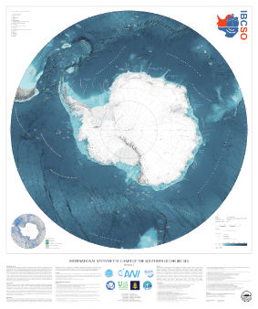
The digital bathymetric model (DBM) of IBCSO Version 2.0 has a 500m x 500m resolution based on a polar stereographic projection (EPSG: 9354) for the area south of 50° S. It is publicly available together with a digital chart for printing.
The projection used for IBCSO v2 was registered in April 2020 under EPSG: 9354.
A .prj file containing the projection string can be downloaded from the PANGAEA website.
If you are using any data from IBCSO v2, please use the following citation:
Dorschel, Boris; Hehemann, Laura; Viquerat, Sacha; Warnke, Fynn; Dreutter, Simon; Schulze Tenberge, Yvonne; Accetella, Daniela; An, Lu; Barrios, Felipe; Bazhenova, Evgenia A; Black, Jenny; Bohoyo, Fernando; Davey, Craig; de Santis, Laura; Escutia Dotti, Carlota; Fremand, Alice C; Fretwell, Peter T; Gales, Jenny A; Gao, Jinyao; Gasperini, Luca; Greenbaum, Jamin S; Henderson Jencks, Jennifer; Hogan, Kelly A; Hong, Jong Kuk; Jakobsson, Martin; Jensen, Laura; Kool, Johnathan; Larin, Sergey; Larter, Robert D; Leitchenkov, German L; Loubrieu, Benoit; Mackay, Kevin; Mayer, Larry; Millan, Romain; Morlighem, Mathieu; Navidad, Francisco; Nitsche, Frank-Oliver; Nogi, Yoshifumi; Pertuisot, Cécile; Post, Alexandra L; Pritchard, Hamish D; Purser, Autun; Rebesco, Michele; Rignot, Eric; Roberts, Jason L; Rovere, Marzia; Ryzhov, Ivan; Sauli, Chiara; Schmitt, Thierry; Silvano, Alessandro; Smith, Jodie E; Snaith, Helen; Tate, Alex; Tinto, Kirsty; Vandenbossche, Philippe; Weatherall, Pauline; Wintersteller, Paul; Yang, Chunguo; Zhang, Tao; Arndt, Jan Erik (2022): The International Bathymetric Chart of the Southern Ocean Version 2 (IBCSO v2). PANGAEA, doi: 10.1594/PANGAEA.937574
The accompanying publication was published in Nature Scientific data:
Dorschel B, Hehemann L, Viquerat S, Warnke F, Dreutter S, Schulze Tenberge Y, Accetella D, An L, Barrios F, Bazhenova EA, Black J, Bohoyo F, Davey C, de Santis L, Escutia Dotti, Carlota Fremand AC, Fretwell PT, Gales JA, Gao J, Gasperini L, Greenbaum JS, Henderson Jencks J, Hogan KA, Hong JK, Jakobsson M, Jensen L, Kool J, Larin S, Larter RD, Leitchenkov GL, Loubrieu B, Mackay K, Mayer L, Millan R, Morlighem M, Navidad F, Nitsche FO, Purser A, Rebesco M, Rignot E, Roberts JL, Rovere M, Ryzhov I, Sauli C, Schmitt T, Silvano A, Smith JE, Snaith H, Tate AJ, Tinto K, Vandenbossche P, Weatherall P, Winterstellar P, Yang C, Zhang T, Arndt JE (2022): International Bathymetric Chart of the Southern Ocean Version 2 (IBCSO v2). doi: 10.1038/s41597-022-01366-7
Database
The IBCSO database currently consists of more than 25 billion data points contributed by 88 institutions from 22 countries. In total, 498 multibeam and 950 singlebeam echo sounding data were building the core data of our database. Digitized soundings from nautical charts, LIDAR, gravity data and regional bathymetric compilations are rounding off the database. A list of datasets used for the compilation of IBCSO v2 can be downloaded here:
Coverage
An overview of included data sources and the spatial distribution can be seen in the source identification map (above right).
The IBCSO group aims to identify data gaps and areas that suffer from low data quality, such as outdated singlebeam data. The IBCSO TID grid can be used to identify areas with high quality multibeam. For an easier access to this information, we also provide a GIS-ready geopackage showing the outline of multibeam and singlebeam surveys contained in IBCSO v2 here:
Data Contributions
If you are holding bathymetric data that is not yet included in the IBCSO database, we encourage you to contribute your data to improve the IBCSO digital bathymetric model for the benefit of all. Contributed data will be acknowledged and will only be used to generate the IBCSO digital bathymetric model. To contribute data, please This email address is being protected from spambots. You need JavaScript enabled to view it..
Cartography data
To enable users to visualize their own data on a map with the IBCSO look and feel, we are offering the base data of the IBCSO printable chart as a georeferenced image. The 'Background' maps contain RGB rasterfiles in GeoTiff format, which is compatible with most GIS programs.
+ Links
Institutions and Data Centres
- Alfred Wegener Institute for Polar and Marine Research (AWI)
- All-Russia Research Institute of Geology and Mineral Resources of the World Ocean (VNIIOkeangeologia)
- Australian Antarctic Program
- Australian Hydrographic Office (AHO)
- British Antarctic Survey (BAS)
- British Oceanographic Data Center (BODC)
- Centro de Investigaciones Oceanográficas e Hidrográficas (CIOH) - Colombia
- General Bathymetric Chart of the Oceans (GEBCO)
- Geoscience Australia (GA)
- Hydrographic and Oceanographic Department Japan Coast Guard (JCG)
- IHO Data Center for Digital Bathymetry (DCDB)
- Institut Francais de Recherche pour l'Exploitation de la Mer (IFREMER)
- Institute of Geological and Nuclear Sciences (GNS) - New Zealand
- Institute of Geological Sciences (IGS) - Ukraine
- Instituto Andaluz de Ciencias de la Tieraa (CSIC) - Spain
- Instituto Geologico y Minero de Espana (IGME)
- Istituto di Scienze Marine (ISMAR) - Italy
- Istituto Nazionale di Oceanografia e di Geofisica Sperimentale (INOGS) - Italy
- Italian Hydrographic Institute (IHI)
- James Cook University (JCU) - Australia
- Japan Agency for Marine-Earth Science and Technology (JAMSTEC)
- Japanese Antarctic Research Expedition (JARE)
- Japan Oceanographic Data Center (JODC)
- Korean Polar Research Institute (KOPRI)
- Lamont-Doherty Earth Observatory (LDEO)
- Marina Difesa - Italy
- Marine National Facility (MNF) - Australia
- National Centers for Environmental Information (NCEI)
- National Geospatial-Intelligence Agency (NGA) - USA
- National Institute of Water and Atmospheric Research (NIWA) - New Zealand
- National Science Foundation (NSF) - USA
- National Institute of Polar Research (NIPR) - Japan
- Norwegian Polar Institute (NPI)
- Scripps Institution of Oceanography (SIO)
- Servicio de Hidrografia Naval (SHN) - Argentina
- Servicio Hidrografico y Oceanografico de la Armada (SHOA) - Chile
- South African Navy Hydrographic Office (SANHO)
- State Oceanic Administration (SOA) - China
- Stockholm University (SU)
- Swiss Polar Institute (SPI)
- Ukraine Antarctic Expedition (UAE)
- United Kingdom Hydrographic Office (UKHO)
- United States Geological Survey (USGS)
- Universidad de Granada (UGR)
- Universita degli Studi di Trieste
- University of Tasmania (UTAS)
- Vernadsky Institute of Geochemistry and Analytical Chemistry - Russia
- Woods Hole Oceanographic Institution (WHOI)
Programs and Groups
- BedMachine v3
- Bed Topography of the Antarctic (BEDMAP2)
- General Bathymetric Chart of the Oceans (GEBCO)
- International Bathymetric Chart of the Arctic Ocean (IBCAO)
- International Hydrographic Organization (IHO)
- Intergovernmental Oceanographic Commission (IOC) of UNESCO
- SCAR Antarctic Digital Database (ADD)
- SCAR Science Group on GeoSciences (GS)
- Scientific Committee on Antarctic Research (SCAR)
- Shuttle Radar Topography Mission (SRTM Plus)
- Southern Ocean Observing System (SOOS)